AAU Herbarium Database |
| New Search Modify Search |
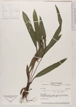
| Collector | Brandbyge, J. |
| Number | 33749 |
| Collected with | Asanza, E. & Werling, L. & Leth-Nissen, S. |
| Country | Ecuador |
| Subpart | NAPO |
| County | |
| Locality | Río Cuyabeno. Hilly primary forest 1.5 km upstream from Puerto Bolívar on the right margin. |
| Coordinates | 0° 6' S 76° 10' W |
| Minimum elevation (m) | 300 |
| Maximum elevation (m) | 300 |
| Start date | 1981/08/19 |
| End date | 1981/08/19 |
| Family | Cyperaceae |
| Identification | Becquerelia clarkei T.Koyama |
| Determined by | E. Maguilla |
| Identification qualifier | |
| Field notes | On forest floor. |
| |
 Other records of Becquerelia clarkei Other records of Becquerelia clarkeiThe map displays only records from the Aarhus Herbarium Database. The records may not represent the full distribution of Becquerelia clarkei |
| New Search Modify Search |