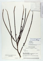
| Collector | Brandbyge, J. |
| Number | 31940 |
| Collected with | Asanza, E. |
| Country | Ecuador |
| Subpart | MORONA-SANTIAGO |
| County | |
| Locality | Taisha. 8-10 km N-NW of the military camp. Primary forest rich in palms. |
| Coordinates | 2° 21' S 77° 31' W |
| Minimum elevation (m) | 450 |
| Maximum elevation (m) | 700 |
| Start date | 1980/06/16 |
| End date | 1980/06/16 |
| Family | Arecaceae |
| Identification | Geonoma longepedunculata Burret |
| Determined by | Borchsenius, F. (AAU), 1996. |
| Identification qualifier | |
| Field notes | 2.2 m. Flowering axis red with green fruits. Leaves up to 1.6 m. |
|
 Other records of Geonoma longepedunculata