AAU Herbarium Database |
| New Search Modify Search |
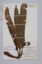
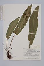
| Collector | Crabbe, J.A. |
| Number | 11833 |
| Collected with | J.W.Dyce, J.H.parker |
| Country | UK |
| Subpart | |
| County | |
| Locality | Vice-county 5, South Somerset: over Stowey parish, Friarn, 1.5 km SW of Nether Stowey. In sandy loam on E & W facing steep roadside banks (soil-covered dry-stone walls) under Cratageus hedges. |
| Coordinates | |
| Minimum elevation (m) | 165 |
| Maximum elevation (m) | 165 |
| Start date | 1968/08/01 |
| End date | 1968/08/01 |
| Family | Aspleniaceae |
| Identification | Phyllitis scolopendrium (L.) Newman |
| Determined by | |
| Identification qualifier | |
| Field notes | |
| |
| This record has no coordinates. Display map with the 1 georeferenced records of Phyllitis scolopendrium in the AAU Herbarium Database. |
| New Search Modify Search |