AAU Herbarium Database |
| New Search Modify Search |
| Collector | Nielsen, I. |
| Number | 1089 |
| Collected with | H. Balslev |
| Country | Brunei |
| Subpart | Temburong |
| County | |
| Locality | Temburong district, Kuala Belalong Field Studies Center, Batu Apoi Forest Reserve, setap shale formation |
| Coordinates | 4° 33' N 115° 9' E |
| Minimum elevation (m) | 0 |
| Maximum elevation (m) | 0 |
| Start date | 1991/00/00 |
| End date | 1992/00/00 |
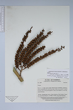
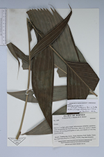
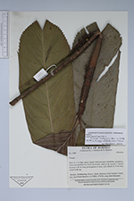
| Family | Arecaceae |
| Identification | Pinanga Blume |
| Determined by | |
| Identification qualifier | |
| Field notes | Stem ca. 1 m high, green ringed. Infructescence infrafoliar, pendulous, rachis and rachillae red. Fruits red at base, white at tip. Leaves 7, sheaths forming a 25 cm long prolongation of stem, each sheath ca. 8 cm long, closed to the top. (Mixed collection: Pinanga ridleyana (entire leaved) and P. aristata (divided leaves)) |
| |
 Other records of Pinanga Other records of PinangaThe map displays only records from the Aarhus Herbarium Database. The records may not represent the full distribution of Pinanga |
| New Search Modify Search |