AAU Herbarium Database |
| New Search Modify Search |
| Collector | Gottsberger, I. |
| Number | 15111090 |
| Collected with | Gottsberger,G. |
| Country | Brazil |
| Subpart | |
| County | |
| Locality | Municipality of Botucatu, 18 km north of Botucatu, 14 km east of São Manuel. Along the São Manuel-Piracicaba highway. Near exRR station The 25 hectare, property of the Departamento de Estrada e Rodagem (DER), are covered by cerrado vegetation (xeromorphic tree & scrub woodland form), remants of an area of about 600 hectare of cerrado |
| Coordinates | 22° 45' S 48° 25' W |
| Minimum elevation (m) | 550 |
| Maximum elevation (m) | 550 |
| Start date | 1990/10/11 |
| End date | 1990/10/11 |
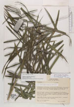
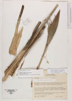
| Family | Arecaceae |
| Identification | Syagrus petraea (Mart.)Becc. |
| Determined by | |
| Identification qualifier | |
| Field notes | Small palm, perhaps somewhat more slender than S. loefgrenii which occurs in the same vegetation |
| |
 Other records of Syagrus petraea Other records of Syagrus petraeaThe map displays only records from the Aarhus Herbarium Database. The records may not represent the full distribution of Syagrus petraea |
| New Search Modify Search |