| Collector | Gottsberger, I. |
| Number | 14141090 |
| Collected with | Gottsberger,G. |
| Country | Brazil |
| Subpart | Sao Paulo |
| County | |
| Locality | Municipality of Botucatu, 18 km north of Botucatu, 14 km east of Sbo Manuel. Along the S-W Manuel-Piracicaba highway. Near exRR station "13 de Maio" |
| Coordinates | 22° 45' S 48° 25' W |
| Minimum elevation (m) | 550 |
| Maximum elevation (m) | 550 |
| Start date | 1990/10/14 |
| End date | 1990/10/14 |
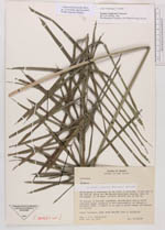
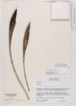
| Family | Arecaceae |
| Identification | Syagrus petraea (Mart.)Becc. |
| Determined by | |
| Identification qualifier | |
| Field notes | 25 hectare of Cerrado vegetation (xeromorphic tree & scrub woodland form), property of the Departamento de Estrada e Rodagem (DER), a remant of an area of about former 600 hectare of cerrado. Small "stemless" palm, more slender than S. loefgrenii |
|
 Other records of Syagrus petraea