AAU Herbarium Database |
| New Search Modify Search |
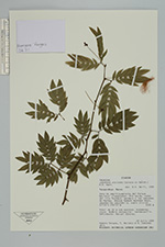
| Collector | Vargas, H. |
| Number | 3671 |
| Collected with | E. Narváez & M. sánchez |
| Country | Ecuador |
| Subpart | Tungurahua |
| County | |
| Locality | Baños. Zona de amortiguamiento del Parque Nacional Llanganates. Río Verde, cañón del rio Pastaza, sendero a las cascadas de Machay. Bosque húmedo montano bajo, vegetación secundaria, suelo aluvial |
| Coordinates | 0° 23' S 78° 17' W |
| Minimum elevation (m) | 1630 |
| Maximum elevation (m) | 1630 |
| Start date | 1999/07/29 |
| End date | 1999/07/29 |
| Family | Fabaceae |
| Identification | Zapoteca aculeata (Spruce ex Benth.) H.M.Hern. |
| Determined by | D.A. Neill |
| Identification qualifier | |
| Field notes | Arbol de 20 m con espinas. Estambres rojos. Nombre vernacular: barbasquillo. Informante: Manuel Sánches |
| |
 Other records of Zapoteca aculeata Other records of Zapoteca aculeataThe map displays only records from the Aarhus Herbarium Database. The records may not represent the full distribution of Zapoteca aculeata |
| New Search Modify Search |