AAU Herbarium Database |
| New Search Modify Search |
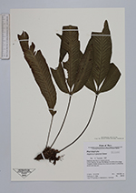
| Collector | Tuomisto, H. |
| Number | 9610 |
| Collected with | C.Bardales, J.Vormisto |
| Country | Peru |
| Subpart | Loreto |
| County | |
| Locality | Maynas. At lower Río Nanay, 6 km NW of the village Tarapoto. Closed-canopy tierra firme rain forest in undulating terrain with caly soil. |
| Coordinates | 3° 46' S 73° 27' W |
| Minimum elevation (m) | 100 |
| Maximum elevation (m) | 200 |
| Start date | 1996/02/21 |
| End date | 1996/02/21 |
| Family | Aspleniaceae |
| Identification | Asplenium pearcei Baker |
| Determined by | T.Tuomisto |
| Identification qualifier | |
| Field notes | Epiphytic less than 2 m above ground. |
| |
 Other records of Asplenium pearcei Other records of Asplenium pearceiThe map displays only records from the Aarhus Herbarium Database. The records may not represent the full distribution of Asplenium pearcei |
| New Search Modify Search |