AAU Herbarium Database |
| New Search Modify Search |
| Collector | Tuomisto, H. |
| Number | 8198 |
| Collected with | K.Ruokolainen, E.Lusa |
| Country | Peru |
| Subpart | Loreto |
| County | |
| Locality | Maynas. Between km 26 of the road Iquitos-Nauta and the river itaya. Remnant patch of closed canopy tierra firme rain forest betweemn cultivated fields. Relatively flat terrain with caly soil. |
| Coordinates | 4° 0' S 73° 24' W |
| Minimum elevation (m) | 100 |
| Maximum elevation (m) | 200 |
| Start date | 1996/01/29 |
| End date | 1996/01/29 |
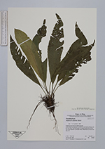
| Family | Aspleniaceae |
| Identification | Asplenium pearcei Baker |
| Determined by | T.Tuomisto |
| Identification qualifier | |
| Field notes | Epiphytic less than 2 m above ground. |
| |
 Other records of Asplenium pearcei Other records of Asplenium pearceiThe map displays only records from the Aarhus Herbarium Database. The records may not represent the full distribution of Asplenium pearcei |
| New Search Modify Search |