AAU Herbarium Database |
| New Search Modify Search |
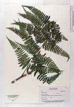
| Collector | Navarrete, H. |
| Number | 496 |
| Collected with | |
| Country | Ecuador |
| Subpart | PICHINCHA |
| County | |
| Locality | km 16 carretero Calacalí - Nanegalito. Bosques al borde del carretero y quebradas. |
| Coordinates | 0° 1' N 78° 34' W |
| Minimum elevation (m) | 2200 |
| Maximum elevation (m) | 2200 |
| Start date | 1992/12/27 |
| End date | 1992/12/27 |
| Family | Dennstaedtiaceae |
| Identification | Hypolepis hostilis (Kunze)C. Presl |
| Determined by | Øllgaard,B. |
| Identification qualifier | |
| Field notes | Hojas arqueadas, peciolo con dos yemas, formando colonias, hoja 2.5 m, 15 pinnas, +ó- alternas subdeltoides, peciolo 1.3 m |
| |
 Other records of Hypolepis hostilis Other records of Hypolepis hostilisThe map displays only records from the Aarhus Herbarium Database. The records may not represent the full distribution of Hypolepis hostilis |
| New Search Modify Search |