AAU Herbarium Database |
| New Search Modify Search |
| Collector | Navarrete, H. |
| Number | 1556 |
| Collected with | |
| Country | Ecuador |
| Subpart | NAPO |
| County | |
| Locality | Camino de herradura que va desde el Chaco hacia Oyacachi, bosques secundarios a los lados del sendero, desde la punta del carretero hasta el puente colgante sobre el río San Juan. |
| Coordinates | 0° 17' S 77° 50' W |
| Minimum elevation (m) | 1750 |
| Maximum elevation (m) | 1750 |
| Start date | 1996/05/07 |
| End date | 1996/05/07 |
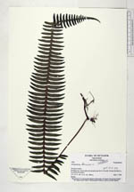
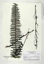
| Family | Polypodiaceae |
| Identification | Polypodium loriceum L |
| Determined by | Navarrete,H. |
| Identification qualifier | |
| Field notes | Epífito |
| |
 Other records of Polypodium loriceum Other records of Polypodium loriceumThe map displays only records from the Aarhus Herbarium Database. The records may not represent the full distribution of Polypodium loriceum |
| New Search Modify Search |