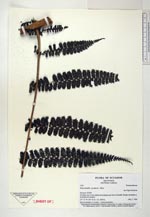
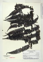
| Collector | Navarrete, H. |
| Number | 1555 |
| Collected with | |
| Country | Ecuador |
| Subpart | NAPO |
| County | |
| Locality | Camino de herradura que va desde el Chaco hacia Oyacachi, bosques secundarios a los lados del sendero, desde la punta del carretero hasta el puente colgante sobre el río San Juan. |
| Coordinates | 0° 17' S 77° 50' W |
| Minimum elevation (m) | 1750 |
| Maximum elevation (m) | 1750 |
| Start date | 1996/05/07 |
| End date | 1996/05/07 |
| Family | Dennstaedtiaceae |
| Identification | Dennstaedtia producta Mett. |
| Determined by | |
| Identification qualifier | |
| Field notes | Hoja 8 m longitud, 1.5 m ancho, escandente, rizoma enterrado, 2 yemas pecioladas |
|
 Other records of Dennstaedtia producta