AAU Herbarium Database |
| New Search Modify Search |
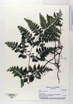
| Collector | Navarrete, H. |
| Number | 1421 |
| Collected with | |
| Country | Ecuador |
| Subpart | NAPO |
| County | |
| Locality | Valle de Oyacachi, bosquede Polylepis frente a la entrada al túnel. |
| Coordinates | 0° 12' S 78° 7' W |
| Minimum elevation (m) | 3680 |
| Maximum elevation (m) | 3680 |
| Start date | 1996/01/05 |
| End date | 1996/01/05 |
| Family | Dennstaedtiaceae |
| Identification | Hypolepis bogotensis H. Karst. |
| Determined by | Øllgaard,B. |
| Identification qualifier | |
| Field notes | Terrestre, yema dormante en el ápice |
| |
 Other records of Hypolepis bogotensis Other records of Hypolepis bogotensisThe map displays only records from the Aarhus Herbarium Database. The records may not represent the full distribution of Hypolepis bogotensis |
| New Search Modify Search |