AAU Herbarium Database |
| New Search Modify Search |
| Collector | Iltis, H.H. |
| Number | E-87 |
| Collected with | M.G.Iltis, D.Dosson, S.Slep |
| Country | Ecuador |
| Subpart | Los Rios |
| County | |
| Locality | (Some maps show this in Pichincha). 9 km E of (11 km by road from) Patricia Pilar (1 km to the E of Escuela Centinelas, a minute settlement forest cleared in 1969), 58 km ENE of Quevedo, on PanAm Highway to Santo Domingo de los Colorados. Virgin fog, moss-and-epiphyte-enshrouded wet tropical rain forest on steep, well drained slopes and ridges, with buttresed trees to 50-60 m, many medium and small palms and Cyclanthaceae in understory. Cretaceous volcanic diabasic bedrock? Soil clayey?. |
| Coordinates | 0° 36' S 79° 18' W |
| Minimum elevation (m) | 300 |
| Maximum elevation (m) | 400 |
| Start date | 1977/07/01 |
| End date | 1977/07/01 |
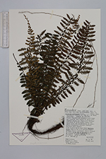
| Family | Aspleniaceae |
| Identification | Asplenium hallii Hook. |
| Determined by | |
| Identification qualifier | |
| Field notes | Epiphytic always on top of 1 m tall treelets. Common on sticks!. |
| |
| Display all 32 georeferenced records of Asplenium Asplenium hallii |
| New Search Modify Search |