AAU Herbarium Database |
| New Search Modify Search |
| Collector | Moore,Jr., H.E. |
| Number | 8204 |
| Collected with | Cetto, M. |
| Country | Guatemala |
| Subpart | El Peten |
| County | |
| Locality | Dense forest surrounding ruins at Tikal. |
| Coordinates | |
| Minimum elevation (m) | 0 |
| Maximum elevation (m) | 0 |
| Start date | 1959/11/05 |
| End date | 1959/11/05 |
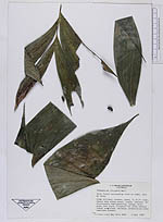
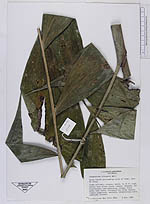
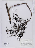
| Family | Arecaceae |
| Identification | Chamaedorea oblongata Mart. |
| Determined by | |
| Identification qualifier | |
| Field notes | Stems solitary, slender, green, to 12 ft. high, leaves deep glossy green, cupped, leathery. Infructescence semi-pendulous, orange, fruit green then black, ellipsoid but often tending toward subglobose, variable. Adventitious roots sometimes present. |
| |
| This record has no coordinates. Display map with the 11 georeferenced records of Chamaedorea oblongata in the AAU Herbarium Database. |
| New Search Modify Search |