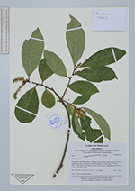
| Collector | Balslev, H. |
| Number | 9943 |
| Collected with | N. Sutjaritjai, V. Chamchumroon, W. & S. Eiserhardt, P. Sumanon, P. Panyadee, P. Kladwong & B. Pakinamhang |
| Country | Thailand |
| Subpart | Chiang Mai |
| County | |
| Locality | Han Dong district. Ob Khan National Park, dry montane forest. Dry dipterocarp forest. Started trail at Ban Mae Khan Nin Tai village (N 18° 45' 02,51''; E 98° 49' 36,71''). Walked in loop 4 km back to Headquarters (N 18° 43' 21,91''; E 98° 49' 17,39''). |
| Coordinates | 18° 43' 2.51'' N 98° 49' 36.71'' E |
| Minimum elevation (m) | 341 |
| Maximum elevation (m) | 403 |
| Start date | 2019/12/17 |
| End date | 2019/12/17 |
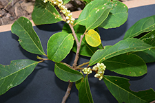
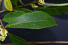
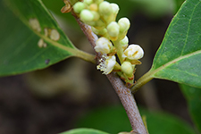
| Family | Symplocaceae |
| Identification | Symplocos racemosa Roxb. � |
| Determined by | |
| Identification qualifier | |
| Field notes | Tree 7 m tall, 19 cm in diameter. |
|