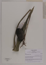
| Collector | Balslev, H. |
| Number | 8500 |
| Collected with | D. Pedersen, L.B. Thostrup, E.L. Tagø, I.M. Østergaard, J. Jensen & C. Grández |
| Country | Peru |
| Subpart | Loreto |
| County | |
| Locality | 214 km SW of Iquitos, 53 km SW of San Martín. Río Samiria, right bank going up. Primary forest on floodplain |
| Coordinates | 5° 7' 4'' S 74° 36' 8'' W |
| Minimum elevation (m) | 121 |
| Maximum elevation (m) | 0 |
| Start date | 2011/07/05 |
| End date | 2011/07/05 |
| Family | Arecaceae |
| Identification | Attalea phalerata Mart. |
| Determined by | Henrik Balslev |
| Identification qualifier | |
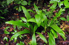
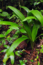
| Field notes | Solitary palm. Seedling. Seed 8 cm long, 5 cm wide. Eophyll entire, 67 cm long, 6,5 cm wide, flat, glabrous. Silica gel sample taken (from leaves). Transect: HB 475, subunit no. 41, inside transect |
|
 Other records of Attalea phalerata