AAU Herbarium Database |
| New Search Modify Search |
| Collector | Balslev, H. |
| Number | 8465 |
| Collected with | M.V. Sørensen, A.K. Brunbjerg & C. Grández |
| Country | Peru |
| Subpart | Madre de Dios |
| County | |
| Locality | Tambopata province. 135 km W of Puerto Maldonado, 12.8 km SW of Santa Rosa, just west of Interoceanica nr 3 towards Río Inambari. Primary forest on terrace |
| Coordinates | 13° 1' 48.24'' S 70° 21' 1.8'' W |
| Minimum elevation (m) | 355 |
| Maximum elevation (m) | 355 |
| Start date | 2011/04/20 |
| End date | 2011/04/20 |
| Family | Arecaceae |
| Identification | Bactris chaveziae A.J.Hend. |
| Determined by | Henrik Balslev |
| Identification qualifier | |
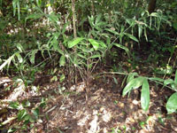
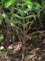
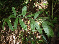
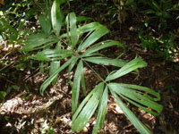
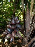
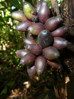
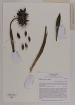
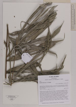
| Field notes | Solitary understory palm. Stem 40 cm high, 1.5 cm thick; internodes 2 cm long, smooth, brown, covered by leaf bases. Leaves 5 per stem; leaf sheath 15.3 cm long, closed; petiole 40 cm long, section round, spiny; spines 3.9 cm long, white with a brown apex; rachis 61 cm long; lamina pinnate, 79 cm long, 42 cm wide, bushy, glabrous; pinnae 12 per side, regularly inserted in groups of 2-5; basal pinna 33.5 cm long, middle pinna 23 cm long, apical pinna 26 cm long. Infructescence infrafoliar; prophyll 9.8 cm long, 1.3 cm wide; peduncular bract 13 cm long, brown, with 0.4 cm long, dark brown spines; peduncle 16 cm long, 0.7 cm wide; rachillae 2 per rachis, 3.2-4 cm long. Fruits 2.2 cm long, 1.1 cm wide, bordeaux/green. Silica gel sample taken. Transect: HB 452, subunit no. 1, outside transect |

| |
 Other records of Bactris chaveziae Other records of Bactris chaveziaeThe map displays only records from the Aarhus Herbarium Database. The records may not represent the full distribution of Bactris chaveziae |
| New Search Modify Search |