AAU Herbarium Database |
| New Search Modify Search |
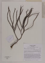
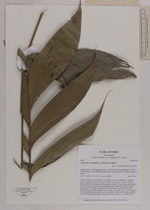
| Collector | Balslev, H. |
| Number | 8460 |
| Collected with | M.V. Sørensen, A.K. Brunbjerg & C. Grández |
| Country | Peru |
| Subpart | Madre de Dios |
| County | |
| Locality | Tambopata province. 113 km W of Puerto Maldonado, 13 km E of Santa Rosa, to the north along sideroad to Interoceanica nr 3. Primary forest on terrace |
| Coordinates | 12° 53' 27.9'' S 70° 11' 5.82'' W |
| Minimum elevation (m) | 265 |
| Maximum elevation (m) | 265 |
| Start date | 2011/04/19 |
| End date | 2011/04/19 |
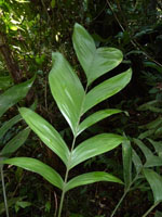
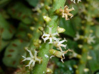
| Family | Arecaceae |
| Identification | Geonoma occidentalis (A.J.Hend.)A.J.Hend. |
| Determined by | Henrik Balslev |
| Identification qualifier | |
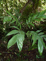
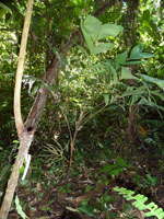
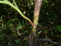
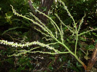
| Field notes | Solitary understory palm. Stem 37 cm high, 2 cm thick; internodes 3 cm long, green, smooth, covered by leaf bases. Leaves 11 per stem; sheath 6 cm long, closed; petiole 45 cm long, section margined; rachis 37,6 cm long; lamina pinnate, 49.5 cm long, 26 cm wide, flat, glabrous; pinnae 4-6 per side, insertion regular; basal pinna 23 cm long, middle pinna 28 cm long, apical pinna 20 cm long. Inflorescence infrafoliar; peduncle 7.4 cm long, 1 cm wide; rachis 11 cm long, 0.6 cm wide; rachillae 9 per rachis, 14.3-25 cm long. Flowers cream, with a pleasant odor. Silica gel sample taken. Transect: HB 450, subunit no. 12, inside transect |
| |
 Other records of Geonoma occidentalis Other records of Geonoma occidentalisThe map displays only records from the Aarhus Herbarium Database. The records may not represent the full distribution of Geonoma occidentalis |
| New Search Modify Search |