AAU Herbarium Database |
| New Search Modify Search |
| Collector | Balslev, H. |
| Number | 8459 |
| Collected with | M.V. Sørensen, A.K. Brunbjerg & C. Grández |
| Country | Peru |
| Subpart | Madre de Dios |
| County | |
| Locality | Tambopata province. 113 km W of Puerto Maldonado, 13 km E of Santa Rosa, to the north along sideroad to Interoceanica nr 3. Primary forest on terrace |
| Coordinates | 12° 53' 28.56'' S 70° 11' 5.9'' W |
| Minimum elevation (m) | 263 |
| Maximum elevation (m) | 263 |
| Start date | 2011/04/19 |
| End date | 2011/04/19 |
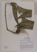
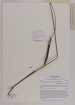
| Family | Arecaceae |
| Identification | Geonoma macrostachys var. acaulis (Mart.)A.J.Hend. |
| Determined by | Henrik Balslev |
| Identification qualifier | |
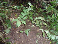
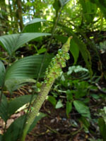
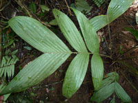
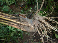
| Field notes | Solitary understory palm. Acaulecent. Base of stem with few visible roots. Leaves 10 per stem; leaf sheath 12 cm long, open; petiole 35 cm long, section round, softly margined; rachis 32 cm long; lamina pinnate, 48 cm long, 40 cm wide, flat, glabrous; pinnae 3 per side, insertion regular; basal pinna 29 cm long, middle pinna 29.5 cm long, apical pinna 25 cm long. Infructescence interfoliar; prophyll 6.5+ cm long, 1.5 cm wide, papery; peduncular bract 15+ cm long, brown, papery; peduncle 53 cm long, 0.5 cm wide; spike 10 cm long, 1 cm wide. Fruits 0.3 cm long, 0.5 cm wide, green. Silica gel sample taken. Transect: HB 450, subunit no. 6, inside transect |
| |
| Display all 211 georeferenced records of Geonoma Geonoma macrostachys var. acaulis |
| New Search Modify Search |