AAU Herbarium Database |
| New Search Modify Search |
| Collector | Balslev, H. |
| Number | 8443 |
| Collected with | M.V. Sørensen, A.K. Brunbjerg & C. Grández |
| Country | Peru |
| Subpart | Madre de Dios |
| County | |
| Locality | Tambopata province. 125 km W of Puerto Maldonado, 6 km N of Santa Rosa. Along Interoceanica nr 3. Primary forest on terrace |
| Coordinates | 12° 52' 10.08'' S 70° 18' 1.14'' W |
| Minimum elevation (m) | 275 |
| Maximum elevation (m) | 275 |
| Start date | 2011/04/16 |
| End date | 2011/04/16 |
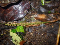
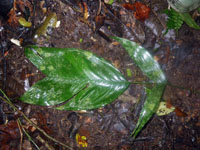
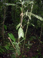
| Family | Arecaceae |
| Identification | Geonoma stricta var. trailii (Burret)A.J.Hend. |
| Determined by | Henrik Balslev |
| Identification qualifier | |
| Field notes | Cespitose understory palm. Stem 78 cm long, 0.8 cm thick; internodes 4.5 cm long, > stem diameter, brown. Leaves 9 per stem; sheath 77 cm long, open; petiole 17 cm long, section round; rachis 26 cm long; lamina pinnate, 34 cm long, 27 cm wide, flat, glabrous; pinnae 2 per side. Inflorescence interfoliar; prophyll 6+ cm long, 0.9 cm wide; peduncular bract 4 cm long, inserted 0.5 cm from base, brown, papery; peduncle 4 cm long, 0.5 cm wide; rachis 12.5 cm long, 0.7 cm wide. Flowers sessile. Silica gel sample taken. Transect: HB 444, subunit no. 2, inside transect |
| |
| Display all 69 georeferenced records of Geonoma Geonoma stricta var. trailii |
| New Search Modify Search |