AAU Herbarium Database |
| New Search Modify Search |
| Collector | Balslev, H. |
| Number | 8442 |
| Collected with | M.V. Sørensen, A.K. Brunbjerg & C. Grández |
| Country | Peru |
| Subpart | Madre de Dios |
| County | |
| Locality | Tambopata province. 129 km W of Puerto Maldonado, 3.5 km N of Santa Rosa. Along Interoceanica nr 3. Primary forest on terrace |
| Coordinates | 12° 53' 43.02'' S 70° 18' 37.2'' W |
| Minimum elevation (m) | 294 |
| Maximum elevation (m) | 294 |
| Start date | 2011/04/15 |
| End date | 2011/04/15 |
| Family | Arecaceae |
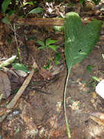
| Identification | Chamaedorea pauciflora Mart. |
| Determined by | Henrik Balslev |
| Identification qualifier | |
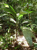
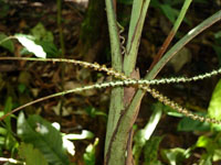
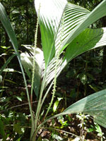
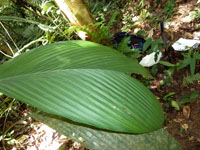
| Field notes | Solitary understory palm. Stem 79 cm long, 1.5 cm thick; internodes 5 cm long, > stem diameter, smooth, green. Leaves 5-6 per stem; sheath 16 cm long, closed; petiole 16 cm long, section margined; rachis 35 cm long; lamina entire, bifid, 56 cm long, 28.5 cm wide, flat, glabrous. Inflorescence interfoliar; peduncular bracts 5.5 cm long, inserted 1.5, 5, 10 cm from base, brown, papery; peduncle 12+ cm long, 0.1 cm wide; rachis 13 cm long, 0.15 cm wide. Silica gel sample taken. Transect: HB 443, subunit no. 20, inside transect |
| |
| Display all 97 georeferenced records of Chamaedorea Chamaedorea pauciflora |
| New Search Modify Search |