AAU Herbarium Database |
| New Search Modify Search |
| Collector | Balslev, H. |
| Number | 8435 |
| Collected with | D. Pedersen, M.V. Sørensen, A.K. Brunbjerg & C. Grández |
| Country | Peru |
| Subpart | Madre de Dios |
| County | |
| Locality | Tambopata province. 17 km NE of Puerto Maldonado towards Iñapari. 6 km East of Interoceanica nr 1. Bella Horizonte Lodge. Primary forest on tierra firme |
| Coordinates | 12° 28' 16.8'' S 69° 5' 7.8'' W |
| Minimum elevation (m) | 242 |
| Maximum elevation (m) | 242 |
| Start date | 2011/04/12 |
| End date | 2011/04/12 |
| Family | Arecaceae |
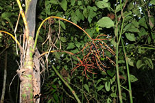
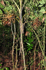
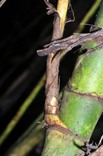
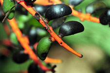
| Identification | Chamaedorea angustisecta Burret |
| Determined by | Henrik Balslev |
| Identification qualifier | |
| Field notes | Solitary understory palm. Stem 247 cm long, 4.5 cm thick; internodes 3-5 cm long, green, smooth. Base of stem with more than 26 visible roots, 6 cm long, 0.5 cm thick. Crownshaft present. Leaves 7 per stem; sheath 60 cm long, closed; petiole 20 cm long, section margined; rachis 156 cm long; lamina pinnate, 173 cm long, flat, glabrous; pinnae 39 per side, insertion regular. Infructescence infrafoliar; peduncular bracts 16+ cm long, inserted 1.5, 3.2, 7, 13, 21.5, 30, 43 and 53 cm from base, brown, papery; peduncle 73 cm long, 1 cm wide; rachis 12 cm long, 1 cm wide; rachillae 19 per rachis 16-22 cm long. Fruits 1.7 cm long, 0.9 cm wide, green/black. Silica gel sample taken. Transect: HB 440, subunit no. 61, inside transect |
| |
 Other records of Chamaedorea angustisecta Other records of Chamaedorea angustisectaThe map displays only records from the Aarhus Herbarium Database. The records may not represent the full distribution of Chamaedorea angustisecta |
| New Search Modify Search |