AAU Herbarium Database |
| New Search Modify Search |
| Collector | Balslev, H. |
| Number | 8426 |
| Collected with | D. Pedersen, M.V. Sørensen, A.K. Brunbjerg & C. Grández |
| Country | Peru |
| Subpart | Madre de Dios |
| County | |
| Locality | Tambopata province. 61 km SW of Puerto Maldonado. SE of Interoceanica nr 3. Primary forest on tierra firme |
| Coordinates | 12° 51' 38.52'' S 69° 40' 53.4'' W |
| Minimum elevation (m) | 255 |
| Maximum elevation (m) | 255 |
| Start date | 2011/04/11 |
| End date | 2011/04/11 |
| Family | Arecaceae |
| Identification | Geonoma stricta var. trailii (Burret)A.J.Hend. |
| Determined by | Henrik Balslev |
| Identification qualifier | |
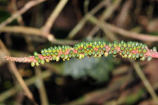
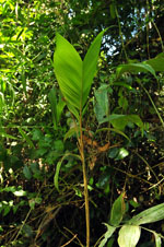
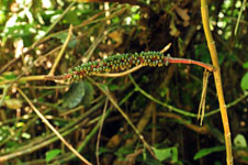
| Field notes | Solitary understory palm. Stem 86 cm long, 1.2 cm thick; internodes 5.5 cm long, > stem diameter, smooth, light brown. Leaves 5 per stem; sheath 23 cm long, closed; petiole 26 cm long, section margined; rachis 48 cm long; lamina pinnate, 62 cm long, 28 cm wide, flat, glabrous, pinnae 3 per side, insertion regular; basal pinna 26 cm long, middle pinna 23 cm long, apical pinna 25 cm long. Infructescence infrafoliar; peduncular bract 12+ cm long, inserted 0.5 cm from base, brown, papery; peduncle 7.5 cm long, 1 cm wide; rachis 22 cm long, 1.5 cm wide. Fruits 0.8 cm long, 0.5 cm wide, green. Silica gel sample taken. Transect: HB 437, subunit no. 18, inside transect |
| |
| Display all 69 georeferenced records of Geonoma Geonoma stricta var. trailii |
| New Search Modify Search |