AAU Herbarium Database |
| New Search Modify Search |
| Collector | Balslev, H. |
| Number | 8423 |
| Collected with | D. Pedersen, M.V. Sørensen, A.K. Brunbjerg & C. Grández |
| Country | Peru |
| Subpart | Madre de Dios |
| County | |
| Locality | Tambopata province. 61 km SW of Puerto Maldonado. S of Interoceanica nr 3. Primary forest on tierra firme |
| Coordinates | 12° 51' 37.26'' S 69° 40' 55.5'' W |
| Minimum elevation (m) | 239 |
| Maximum elevation (m) | 239 |
| Start date | 2011/04/11 |
| End date | 2011/04/11 |
| Family | Arecaceae |
| Identification | Bactris hirta var. spruceana (Trail) A.J.Hend. |
| Determined by | Henrik Balslev |
| Identification qualifier | |
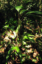
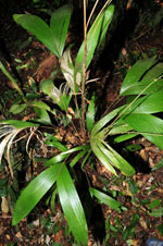
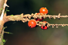
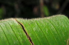
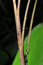
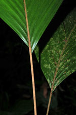
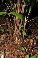
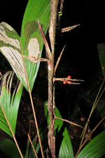
| Field notes | Cespitose understory palm. Stem 50 cm long, 1.2 cm thick; internodes 4 cm long, > stem diameter, brown, smooth, covered by leaf bases. Leaves 5 per stem; sheath 14.5 cm long, closed, with 1.8 cm long, black spines; petiole 33 cm long; rachis 19 cm long; lamina entire, bifid, 47 cm long, 26 cm wide, flat, hairy. Infructescence infrafoliar; prophyll 5 cm long, 1 cm wide, papery; peduncular bract 11 cm long, inserted 1.5 cm from base, brown, papery, with 0.5 cm long, black spines; peduncle 1.7 cm long, 0.4 cm wide; rachillae 2 per rachis, 4-4.7 cm long. Fruit 0.8 cm long, 0.7 cm wide, red with 0.1 cm long, brown spines. Silica gel sample taken. Transect: HB 437, subunit no. 1, inside transect |
| |
 Other records of Bactris hirta var. spruceana Other records of Bactris hirta var. spruceanaThe map displays only records from the Aarhus Herbarium Database. The records may not represent the full distribution of Bactris hirta var. spruceana |
| New Search Modify Search |