AAU Herbarium Database |
| New Search Modify Search |
| Collector | Balslev, H. |
| Number | 8420 |
| Collected with | D. Pedersen, M.V. Sørensen, A.K. Brunbjerg & C. Grández |
| Country | Peru |
| Subpart | Madre de Dios |
| County | |
| Locality | Tambopata province. 17 km W of Puerto Maldonado. Along Interoceanica nr 3. Primary forest on tierra firme |
| Coordinates | 12° 39' 3.06'' S 69° 19' 58.08'' W |
| Minimum elevation (m) | 230 |
| Maximum elevation (m) | 230 |
| Start date | 2011/04/09 |
| End date | 2011/04/09 |
| Family | Arecaceae |
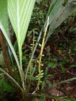
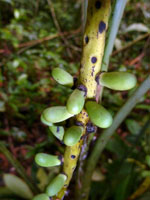
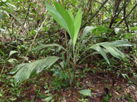
| Identification | Chamaedorea pauciflora Mart. |
| Determined by | Henrik Balslev |
| Identification qualifier | |
| Field notes | Solitary understory palm. Stem 51 cm high, 2 cm thick; internodes 5-5.5 cm long, < stem diameter, green, smooth. Base of stem with 10 visible roots, 4+ cm long, 0.4 cm wide. Leaves 9 per stem; sheath 25+ cm long, closed; petiole 20 cm long, section margined; rachis 55 cm long; lamina entire, bifid, 78 cm long, 31 cm wide, flat, glabrous. Infructescence interfoliar; peduncular bracts inserted 3, 8, 13 cm from base, brown, papery; peduncle 21.5 cm long, 0.7 cm wide; rachis 27 cm long, 0.8 cm wide. Fruits 1.3 cm long, 0.7 cm wide, green. Silica gel sample taken. Transect: HB 435, subunit no. 42, inside transect |
| |
| Display all 97 georeferenced records of Chamaedorea Chamaedorea pauciflora |
| New Search Modify Search |