AAU Herbarium Database |
| New Search Modify Search |
| Collector | Balslev, H. |
| Number | 8413 |
| Collected with | D. Pedersen, M.V. Sørensen, A.K. Brunbjerg & C. Grández |
| Country | Peru |
| Subpart | Madre de Dios |
| County | |
| Locality | Tahuamanu province. 164 km N of Puerto Maldonado, 23 km S of Iñapari. Along Interoceanica nr 1. Primary forest on tierra firme |
| Coordinates | 11° 9' 21.66'' S 69° 33' 10.2'' W |
| Minimum elevation (m) | 317 |
| Maximum elevation (m) | 317 |
| Start date | 2011/04/06 |
| End date | 2011/04/06 |
| Family | Arecaceae |
| Identification | Bactris chaveziae A.J.Hend. |
| Determined by | Henrik Balslev |
| Identification qualifier | |
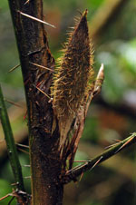
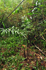
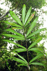
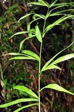
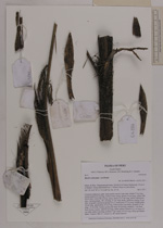
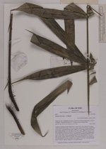
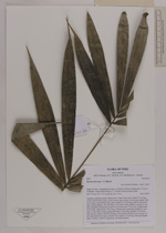
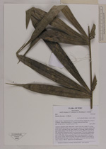
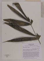
| Field notes | Cespitose understory palm. Stem aerial. Leaves 5 per stem; sheath 27 cm long, closed; petiole 64 cm long, section round, spiny; spines 3-4 cm long, yellow with brown apex; rachis 88 cm long, spiny; spines 2.5-3 cm long, yellow with brown apex; lamina pinnate, 105 cm long, 57 cm wide, bushy, glabrous; pinnae 21 per side, irregularly inserted in groups of 2-5; basal pinna 17 cm long, middle pinna 30 cm long, apical pinna 19 cm long. Inflorescence interfoliar; prophyll 13 cm long, 1.8 cm wide, woody; peduncular bract 16 cm long, inserted 11 cm from base, brown, woody, with 0.8 cm long, yellow spines; peduncle 10 cm long, 0.4 cm wide; rachis 0 cm long; rachillae 2 per rachis, 4-5 cm long. Silica gel sample taken. Transect: HB 431, subunit no. 60, inside transect |
| |
 Other records of Bactris chaveziae Other records of Bactris chaveziaeThe map displays only records from the Aarhus Herbarium Database. The records may not represent the full distribution of Bactris chaveziae |
| New Search Modify Search |