AAU Herbarium Database |
| New Search Modify Search |
| Collector | Balslev, H. |
| Number | 8404 |
| Collected with | D. Pedersen, M.V. Sørensen, A.K. Brunbjerg & C. Grández |
| Country | Peru |
| Subpart | Madre de Dios |
| County | |
| Locality | Tahuamanu province. 176 km N of Puerto Maldonado, 11 km S of Iñapari. Along Interoceanica nr 1. Primary forest on tierra firme |
| Coordinates | 11° 2' 36.24'' S 69° 33' 46.56'' W |
| Minimum elevation (m) | 305 |
| Maximum elevation (m) | 305 |
| Start date | 2011/04/04 |
| End date | 2011/04/04 |
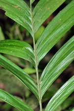
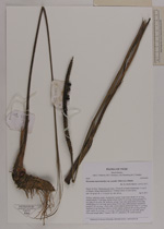
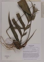
| Family | Arecaceae |
| Identification | Geonoma macrostachys var. acaulis (Mart.)A.J.Hend. |
| Determined by | Henrik Balslev |
| Identification qualifier | |
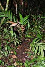
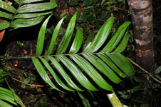
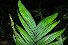
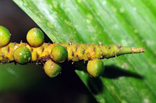
| Field notes | Solitary understory palm. Acaulecent. Leaves 10 per stem; sheath 19 cm long, closed; petiole 74 cm long, section round; rachis 54 cm long; lamina pinnate, 73 cm long, 40 cm wide, flat, glabrous; pinnae 7 per side; basal pinna 30 cm long, middle pinna 32.5 cm long, apical pinna 30 cm long. Infructescence interfoliar; prophyll 18.5 cm long, 1.8 cm wide, texture papery; peduncular bract 21 cm long, inserted 0.2 cm from base, brown, texture papery; peduncle 85 cm long, 0.6 cm wide; rachis 16 cm long, 1.5 cm wide. Fruits 0.6 cm long, 0.4 cm wide, green. Silica gel sample taken. Transect: HB 427, subunit no. 91, inside transect |
| |
| Display all 211 georeferenced records of Geonoma Geonoma macrostachys var. acaulis |
| New Search Modify Search |