AAU Herbarium Database |
| New Search Modify Search |
| Collector | Balslev, H. |
| Number | 8384 |
| Collected with | D. Pedersen, M.V. Sørensen, A.K. Brunbjerg & C. Grández |
| Country | Peru |
| Subpart | Madre de Dios |
| County | |
| Locality | Tambopata province. 41 km E of Puerto Maldonado, 3.4 km W of Palma Real. Reserva Tambopata, south bank of Río Madre de Dios. Primary forest on tierra firme |
| Coordinates | 12° 31' 5.28'' S 68° 48' 32.7'' W |
| Minimum elevation (m) | 205 |
| Maximum elevation (m) | 205 |
| Start date | 2011/03/29 |
| End date | 2011/03/29 |
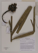
| Family | Arecaceae |
| Identification | Bactris acanthocarpa Mart. |
| Determined by | Henrik Balslev |
| Identification qualifier | |
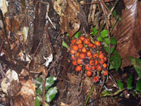
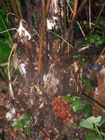
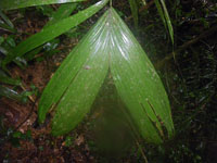
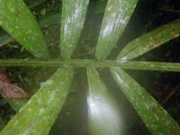
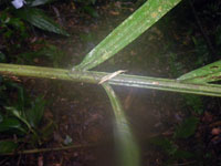
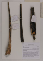
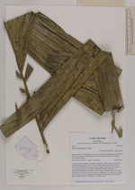
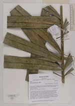
| Field notes | Cespitose understory palm. Acaulecent. Roots few visible. Leaves 19 per stem; sheath 50 cm long, open, with 1 cm long, black spines; petiole 200 cm long, section round; rachis 183 cm long; lamina pinnate, 240 cm long, 100 cm wide, bushy, glabrous; pinnae 17 per side, irregularly inserted in groups of 1-3. Infructescence infrafoliar; peduncle 14.5 cm long, 2 cm wide, with 0.3 cm long, black spines; rachis 6 cm long, 0.3 cm wide; rachillae 20+ per rachis, 4-5 cm long. Fruits globose, 1.2x1.2 cm, orange, with minute black spines. Silica gel sample taken. Transect: HB 421, subunit no. 21, inside transect |
| |
 Other records of Bactris acanthocarpa Other records of Bactris acanthocarpaThe map displays only records from the Aarhus Herbarium Database. The records may not represent the full distribution of Bactris acanthocarpa |
| New Search Modify Search |