AAU Herbarium Database |
| New Search Modify Search |
| Collector | Balslev, H. |
| Number | 8380 |
| Collected with | D. Pedersen, M.V. Sørensen, A.K. Brunbjerg & C. Grández |
| Country | Peru |
| Subpart | Madre de Dios |
| County | |
| Locality | Tambopata province. 37 km E of Puerto Maldonado, 10 km W of Palma Real. Reserva Tambopata, north bank of Río Madre de Dios. Primary forest on terrace. |
| Coordinates | 12° 28' 12.72'' S 68° 51' 40.98'' W |
| Minimum elevation (m) | 210 |
| Maximum elevation (m) | 210 |
| Start date | 2011/03/29 |
| End date | 2011/03/29 |
| Family | Arecaceae |
| Identification | Bactris maraja var. trichospatha (Trail)A.J. Hend. |
| Determined by | Henrik Balslev |
| Identification qualifier | |
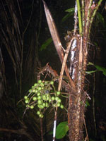
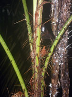
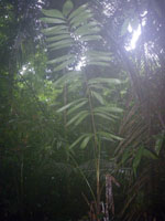
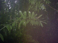
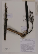
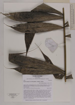
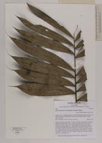
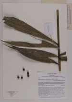
| Field notes | Cespitose understory palm. Stem 1 m high, 1 cm thick, rough. Leaves 4 per stem; sheath 24 cm long, closed, with 1-3 cm long, black spines; rachis 86 cm long; lamina pinnate, 84 cm long, 48 cm wide, flat, glabrous; pinnae 21 per side, irregularly inserted in groups of 3-4; basal pinnae 20 cm long, middle pinnae 24 cm long, apical pinnae 8 cm long. Infructescence: Prophyll 16 cm long, 2.5 cm wide, papery; peduncular bract 42 cm long, brown, woody; peduncle 31 cm long, 1 cm wide; rachis 8 cm long, 0.3 cm wide; rachillae 13 per rachis, 6-9 cm long. Fruits green, 1 cm long, 1.3 cm wide. Silica gel sample taken. Transect: HB 420, subunit no. 10, inside transect |
| |
 Other records of Bactris maraja var. trichospatha Other records of Bactris maraja var. trichospathaThe map displays only records from the Aarhus Herbarium Database. The records may not represent the full distribution of Bactris maraja var. trichospatha |
| New Search Modify Search |