AAU Herbarium Database |
| New Search Modify Search |
| Collector | Balslev, H. |
| Number | 8379 |
| Collected with | D. Pedersen, M.V. Sørensen, A.K. Brunbjerg & C. Grández |
| Country | Peru |
| Subpart | Madre de Dios |
| County | |
| Locality | Tambopata province. 37 km E of Puerto Maldonado, 10.2 km NW of Palma Real. Reserva Tambopata, on north bank of Río Madre de Dios. Primary forest on tierra firme |
| Coordinates | 12° 28' 12.66'' S 68° 51' 41.4'' W |
| Minimum elevation (m) | 201 |
| Maximum elevation (m) | 201 |
| Start date | 2011/03/29 |
| End date | 2011/03/29 |
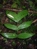
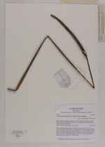
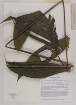
| Family | Arecaceae |
| Identification | Geonoma macrostachys var. acaulis (Mart.)A.J.Hend. |
| Determined by | Henrik Balslev |
| Identification qualifier | |
| Field notes | Solitary understory palm. Acaulecent. Leaves 6 per stem; petiole 98 cm long; rachis 39 cm long; lamina pinnate, 57 cm long, 40 cm wide, flat, glabrous; pinnae 3 per side; basal pinna 26 cm long; middle pinna 30 cm long; apical pinna 30 cm long. Infructescence interfoliar; peduncle 50 cm long, 0.3 cm wide; rachis 18 cm long, 0.7 cm wide. Fruits globose, green, 0.6x0,6 cm . Silica gel sample taken. Transect: HB 420, subunit no. 7, inside transect |
| |
| Display all 211 georeferenced records of Geonoma Geonoma macrostachys var. acaulis |
| New Search Modify Search |