AAU Herbarium Database |
| New Search Modify Search |
| Collector | Balslev, H. |
| Number | 8374 |
| Collected with | D. Pedersen, M.V. Sørensen, A.K. Brunbjerg & C. Grández |
| Country | Peru |
| Subpart | Madre de Dios |
| County | |
| Locality | Tambopata province. 41 km E of Puerto Maldonado, 5 km W of Palma Real. Reserva Tambopata, on north bank of Río Madre de Dios. Primary forest on floodplain |
| Coordinates | 12° 30' 0'' S 68° 48' .48'' W |
| Minimum elevation (m) | 184 |
| Maximum elevation (m) | 184 |
| Start date | 2011/03/26 |
| End date | 2011/03/26 |
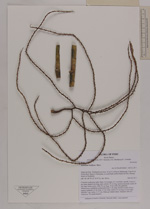
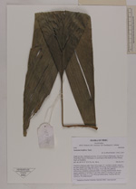
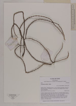
| Family | Arecaceae |
| Identification | Geonoma laxiflora Mart. |
| Determined by | Henrik Balslev |
| Identification qualifier | |
| Field notes | Cespitose understory palm. Stem 3.05 m high, 0.5-1 cm thick, smooth. Leaves 5 per stem; sheath 8 cm long, open; petiole 19 cm long, section margined; rachis 30 cm long; lamina entire, bifid, 50 cm long, 19 cm wide, flat, glabrous. Inflorescence infrafoliar; peduncular bract 3 cm long, inserted at base, brown, papery; peduncle 4.5 cm long, 0.7 cm wide; rachis 4.5 cm long, 0.3 cm wide; rachillae 7 per rachis, 21-31 cm. Silica gel sample taken. Transect: HB 415, subunit no. 70, inside transect |
| |
 Other records of Geonoma laxiflora Other records of Geonoma laxifloraThe map displays only records from the Aarhus Herbarium Database. The records may not represent the full distribution of Geonoma laxiflora |
| New Search Modify Search |