AAU Herbarium Database |
| New Search Modify Search |
| Collector | Balslev, H. |
| Number | 8362 |
| Collected with | D. Pedersen, M.V. Sørensen, A.K. Brunbjerg & C. Grández |
| Country | Peru |
| Subpart | Madre de Dios |
| County | |
| Locality | Tambopata province. 39 km E of Puerto Maldonado, 5.4 km W of Palma Real. Reserva Tambopata, south bank of Río Madre de Dios. Primary forest tierra firme |
| Coordinates | 12° 30' 56.22'' S 68° 49' 40.26'' W |
| Minimum elevation (m) | 197 |
| Maximum elevation (m) | 197 |
| Start date | 2011/03/25 |
| End date | 2011/03/25 |
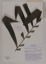
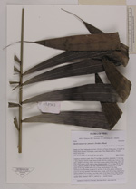
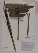
| Family | Arecaceae |
| Identification | Bactris maraja var. juruensis (Trail)A.J.Hend. |
| Determined by | Henrik Balslev |
| Identification qualifier | |
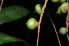
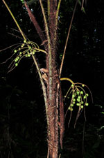
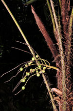
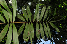
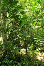
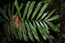
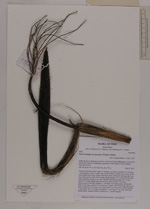
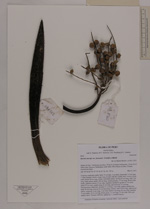
| Field notes | Cespitose understory palm. Stem 73 cm high, 3 cm thick; internodes 7.5 cm long, > stem diameter, brown, rough; base of stem with few visible roots. Leaves 10 per stem; sheath 46 cm long, closed, with black spines; petiole 65 cm long, with 1 cm long, black spines; rachis 160 cm long; lamina pinnate, 177 cm long, 88 cm wide, bushy, glabrous; pinnae 21 per side, regularly inserted in groups of 1-4; basal pinna 42 cm long, middle pinna 43 cm long, apical pinnae 21 cm long. Infructescence interfoliar; prophyll 11 cm long, 5 cm wide, papery; peduncular bract 36 cm long, inserted 10 cm from base, woody, with 0.8 cm long, light brown spines; peduncle 16 cm long, 1 cm wide; rachis 4 cm long, 0.6 cm wide; rachillae 11 per rachis, 10-12 cm long. Fruits green, 1.1 cm long, 1.5 cm wide. Silica gel sample taken. Transect: HB 412, subunit no. 1, outside transect |
| |
 Other records of Bactris maraja var. juruensis Other records of Bactris maraja var. juruensisThe map displays only records from the Aarhus Herbarium Database. The records may not represent the full distribution of Bactris maraja var. juruensis |
| New Search Modify Search |