AAU Herbarium Database |
| New Search Modify Search |
| Collector | Balslev, H. |
| Number | 8361 |
| Collected with | D. Pedersen, M.V. Sørensen, A.K. Brunbjerg & C. Grández |
| Country | Peru |
| Subpart | Madre de Dios |
| County | |
| Locality | Tambopata province. 39 km E of Puerto Maldonado, 5.4 km W of Palma Real. Reserva Tambopata, south bank of Río Madre de Dios. Primary forest tierra firme |
| Coordinates | 12° 30' 56.7'' S 68° 49' 40.44'' W |
| Minimum elevation (m) | 195 |
| Maximum elevation (m) | 195 |
| Start date | 2011/03/25 |
| End date | 2011/03/25 |
| Family | Arecaceae |
| Identification | Geonoma occidentalis (A.J.Hend.)A.J.Hend. |
| Determined by | Henrik Balslev |
| Identification qualifier | |
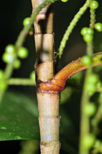
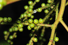
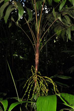
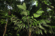
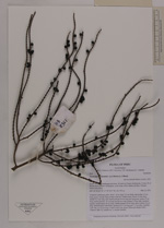
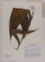
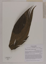
| Field notes | Cespitose understory palm. Stem 1.65 m high, 2.5 cm thick; internodes 2.5 cm long, green, smooth, base of stem with few visible roots. Leaves 14 per stem; sheath 19.5 cm long and closed; petiole 44 cm long and margined; rachis 57 cm long; lamina pinnate, 74 cm long and 40 cm wide; pinnae 3-4 per side, insertion regular; basal pinnae 40 cm long, middle pinnae 38 cm long, apical pinnae 30 cm long. Infructescence infrafoliar; peduncle 8.5 cm long and 1.5 cm wide; rachillae 7 per side, 21-23 cm long. Fruits 0.5x0.5 cm, green. Silica gel sample taken. Transect: HB 412, subunit no. 1, outside transect |
| |
 Other records of Geonoma occidentalis Other records of Geonoma occidentalisThe map displays only records from the Aarhus Herbarium Database. The records may not represent the full distribution of Geonoma occidentalis |
| New Search Modify Search |