AAU Herbarium Database |
| New Search Modify Search |
| Collector | Balslev, H. |
| Number | 8348 |
| Collected with | Dennis Pedersen & Roberto Carrillo |
| Country | Ecuador |
| Subpart | Santo Domingo |
| County | |
| Locality | 5 km SE of Sto. Domingo. Forest fragment on farm of Sr. Cuadrado. Primary forest on terra firme |
| Coordinates | 0° 17' 15'' 79° 8' 22'' |
| Minimum elevation (m) | 510 |
| Maximum elevation (m) | 510 |
| Start date | 2011/01/09 |
| End date | 2011/01/09 |
| Family | Arecaceae |
| Identification | Chamaedorea deneversiana Grayum & Hodell |
| Determined by | Balslev H. |
| Identification qualifier | |
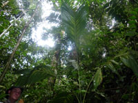
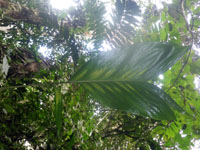
| Field notes | Solitary sterile understory palm. Stem 3 m long, 2 cm in diameter, smooth, procumbent; internodes 10 cm long; base of stem with few visible roots. Leaves 3; sheath 30 cm long, closed; petiole 60 cm long, section round; rachis 35 cm long; lamina entire, 50 cm long, 50 cm wide, flat. Transect RC24, subunit no. 052, in transect |
| |
 Other records of Chamaedorea deneversiana Other records of Chamaedorea deneversianaThe map displays only records from the Aarhus Herbarium Database. The records may not represent the full distribution of Chamaedorea deneversiana |
| New Search Modify Search |