AAU Herbarium Database |
| New Search Modify Search |
| Collector | Balslev, H. |
| Number | 8309 |
| Collected with | Alexander Parada & Yanina Inturias |
| Country | Bolivia |
| Subpart | La Paz |
| County | |
| Locality | Franz Tamayo province. 164 km N of La Paz, 37 km SSE of Apolo, 2 km SSE of Munaypata. Montane rainforest on steep slopes |
| Coordinates | 15° 2' 22.1'' S 68° 18' 17.1'' W |
| Minimum elevation (m) | 1021 |
| Maximum elevation (m) | 1021 |
| Start date | 2010/08/16 |
| End date | 0/00/00 |
| Family | Arecaceae |
| Identification | Geonoma interrupta var. euspatha (Burret)A.J.Hend. |
| Determined by | Balslev H. |
| Identification qualifier | |
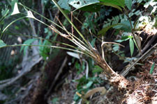
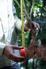
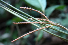
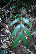
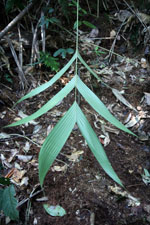
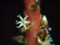
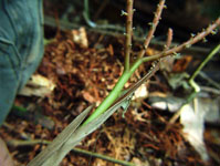
| Field notes | Solitary understory palm. Stem 7 cm long, 2.3 cm thick, smooth; internodes 0.3 cm long, yellow; base of stem with few visible roots. Leaves 6; leaf sheath 12 cm long, open; petiole 33 cm long, section margined; rachis 33 cm long; lamina pinnate, 60 cm long, 40 cm wide, glabrous; pinnae 3 per side, regularly inserted; middle pinna 37 cm long. Inflorescence interfoliar; prophyll 23 cm long, 0.8 cm wide, woody; peduncular bract 27 cm long, brown, woody; peduncle 20 cm long, 0.5 cm wide; rachis 1.5 cm long, 0.4 cm wide; rachillae 3, 10-11.5 cm long. Flowers sunken, cream. Transect HB156, subunit no. 022, inside transect; UTM: 19L-574731-8337192 |
| |
 Other records of Geonoma interrupta var. euspatha Other records of Geonoma interrupta var. euspathaThe map displays only records from the Aarhus Herbarium Database. The records may not represent the full distribution of Geonoma interrupta var. euspatha |
| New Search Modify Search |