AAU Herbarium Database |
| New Search Modify Search |
| Collector | Balslev, H. |
| Number | 8299 |
| Collected with | Alexander Parada & Yanina Inturias |
| Country | Bolivia |
| Subpart | La Paz |
| County | |
| Locality | Franz Tamayo province. 170 km N of La Paz, 29 km S of Apolo. Calabata, 3.2 km S of Correo (6 km by road) along the Apolo - La Paz road. Montane rainforest along ridge SE of the road |
| Coordinates | 14° 59' 1.8'' S 68° 25' 59.9'' W |
| Minimum elevation (m) | 1627 |
| Maximum elevation (m) | 1627 |
| Start date | 2010/08/14 |
| End date | 0/00/00 |
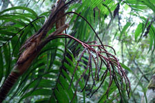
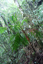
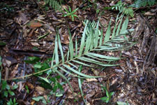
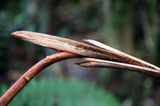
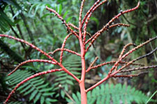
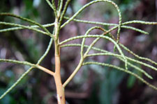
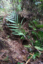
| Family | Arecaceae |
| Identification | Geonoma undata Klotzsch |
| Determined by | Balslev H. |
| Identification qualifier | |
| Field notes | Solitary understory palm. Stem 2.8 m long, 3.5 cm diam, smooth; internodes 3 cm long, yellow; base of stem with few visible roots. Number of leaves 9; leaf sheath 30 cm long, open; petiole 50 cm long, section margined; rachis 94 cm long; lamina pinnate, 120 cm long, 70 cm wide, glabrous; pinnae 15 per side, regularly inserted; basal pinna 38 cm long, middle pinna 58 cm long, apical pinna 38 cm long. Inflorescence interfoliar; peduncle 23 cm long, 1.8 cm wide; rachis 16 cm long, 0.8 cm wide; rachillae 4, 17-25 cm long. Flowers sessile, cream. Transect HB154, subunit no. 013, inside transect; UTM: 19L-560928-8343385 |
| |
| Display all 75 georeferenced records of Geonoma Geonoma undata |
| New Search Modify Search |