AAU Herbarium Database |
| New Search Modify Search |
| Collector | Balslev, H. |
| Number | 8278 |
| Collected with | Alexander Parada & Yanina Inturias |
| Country | Bolivia |
| Subpart | Cochabamba |
| County | |
| Locality | Carrasco Province. 149 Km ENE of Cochabamba, km 8 on the Ivirganzama - Puerto Villaroel road, side-road to the Cochabamba - Sta. Cruz highway. Lowland tropical rain forest patch, 1.4 km W of the road |
| Coordinates | 16° 58' 57.9'' S 64° 49' 59'' W |
| Minimum elevation (m) | 219 |
| Maximum elevation (m) | 219 |
| Start date | 2010/08/04 |
| End date | 0/00/00 |
| Family | Arecaceae |
| Identification | Desmoncus polyacanthos Mart. |
| Determined by | Balslev H. |
| Identification qualifier | |
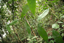
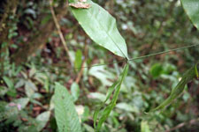
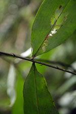
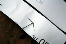
| Field notes | Solitary understory palm. Liana. Stem 2 m long, 0.9 cm thick, covered by leaf bases; internodes 18 cm long, light green. Leaves 11; leaf sheath 18 cm long, closed, with 2 cm long cream-colored spines with black apices; petiole 12 cm long, section round, with 1 cm long, black, curved spines; rachis 31 cm long, with 0.8 cm long, black, curved spines; lamina pinnate, 45 cm long, 35 cm wide, glabrous; pinnae 3 per side, regularly inserted; basal pinna 20 cm long, middle pinna 20 cm, long, apical pinna 20 cm long. Sterile. Transect HB146, subunit no. 053, inside transect; UTM: 20K-304839-8121440 |
| |
| Display all 53 georeferenced records of Desmoncus Desmoncus polyacanthos |
| New Search Modify Search |