AAU Herbarium Database |
| New Search Modify Search |
| Collector | Balslev, H. |
| Number | 8276 |
| Collected with | Alexander Parada & Yanina Inturias |
| Country | Bolivia |
| Subpart | Cochabamba |
| County | |
| Locality | Carrasco Province. 149 Km ENE of Cochabamba, km 8 on the Ivirganzama - Puerto Villaroel road, side-road to the Cochabamba - Sta. Cruz highway. Lowland tropical rain forest patch, 1.4 km W of the road |
| Coordinates | 16° 58' 53.5'' S 64° 49' 55.6'' W |
| Minimum elevation (m) | 213 |
| Maximum elevation (m) | 213 |
| Start date | 2010/08/04 |
| End date | 0/00/00 |
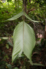
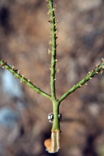
| Family | Arecaceae |
| Identification | Geonoma brevispatha Barb-Rodr. |
| Determined by | Balslev H. |
| Identification qualifier | |
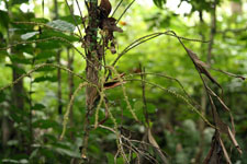
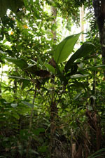
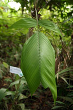
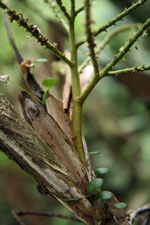
| Field notes | Solitary understory palm. Stem 1.45 m long, smooth; internodes 1.5 cm long, cream. Leaves 16, leaf sheath 15 cm long, open; petiole 25 cm long, section margined; rachis 35 cm long; lamina 50 cm long, 20 cm wide, glabrous; pinnae 2 per side. Inflorescence infrafoliar; peduncle 10 cm long, 0.8 cm wide; rachis 5 cm long, 0.4 cm wide; rachillae 11, 22-28 cm long. Flowers cream-colored. Transect HB146, subunit no. 006, inside transect; UTM: 20K-304938-8121578 |
| |
 Other records of Geonoma brevispatha Other records of Geonoma brevispathaThe map displays only records from the Aarhus Herbarium Database. The records may not represent the full distribution of Geonoma brevispatha |
| New Search Modify Search |