AAU Herbarium Database |
| New Search Modify Search |
| Collector | Balslev, H. |
| Number | 8267 |
| Collected with | Alexander Parada & Yanina Inturias |
| Country | Bolivia |
| Subpart | Cochabamba |
| County | |
| Locality | Carrasco Province. 150 Km ENE of Cochabamba, km 7 on the Ivirganzama - Puerto Villaroel road, side-road to the Cochabamba - Sta. Cruz highway. Lowland tropical rain forest patch, 1 km E of the road |
| Coordinates | 16° 59' 21.4'' S 64° 48' 39.9'' W |
| Minimum elevation (m) | 218 |
| Maximum elevation (m) | 218 |
| Start date | 2010/08/03 |
| End date | 0/00/00 |
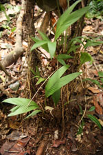
| Family | Arecaceae |
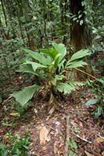
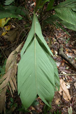
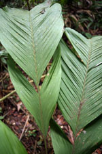
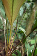
| Identification | Geonoma brongniartii Mart. |
| Determined by | Balslev H. |
| Identification qualifier | |
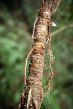
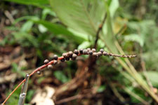
| Field notes | Solitary understory palm. Roots visible, more than 20, 15 cm long, 0.3 cm thick. Stem 44 cm long, 2.5 cm thick; internodes 0.5-0.8 cm long, yellow. Leaves 7; leaf sheath 10 cm long, open; petiole 20 cm long, section round; rachis 55 cm long; lamina pinnate, 65 cm long, 26 cm wide, glabrous; pinnae 2-3 per side. Inflorescence interfoliar; peduncle 23 cm long, 0.4 cm wide; rachis 15 cm long, 0.4 cm wide. Flowers sessile, cream. Fruits 0.5 x 0.5 cm, black. Transect HB144, subunit no. 004, inside transect; UTM: 20K-307185-8120741 |
| |
| Display all 110 georeferenced records of Geonoma Geonoma brongniartii |
| New Search Modify Search |