AAU Herbarium Database |
| New Search Modify Search |
| Collector | Balslev, H. |
| Number | 8264 |
| Collected with | Alexander Parada & Yanina Inturias |
| Country | Bolivia |
| Subpart | Cochabamba |
| County | |
| Locality | Carrasco Province. 152 Km ENE of Cochabamba, 11 km SE of the village of Ivirganzama, along the Cochabamba - Sta. Cruz highway. Valle del Sacta. Lowland tropical rain forest |
| Coordinates | 17° 4' 45.9'' S 64° 45' 57.5'' W |
| Minimum elevation (m) | 240 |
| Maximum elevation (m) | 240 |
| Start date | 2010/08/03 |
| End date | 0/00/00 |
| Family | Arecaceae |
| Identification | Geonoma macrostachys var. acaulis (Mart.)A.J.Hend. |
| Determined by | Balslev H. |
| Identification qualifier | |
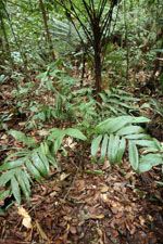
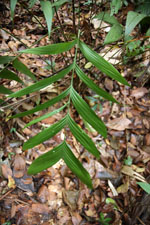
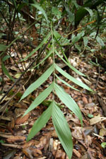
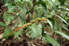
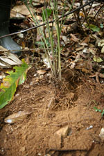
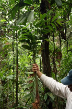
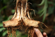
| Field notes | Solitary understory palm. Acaulescent. Leaves 10; leaf sheath 13 cm long, open; petiole 50 cm long, section round; rachis 39 cm long; lamina pinnate, 58 cm long, 40 cm wide, glabrous; pinnae 5-7 per side, regularly inserted; basal pinna 25 cm long, middle pinna 25 cm long, apical pinna 20 cm long. Infructescence interfoliar; peduncle 60 cm long, 0.5 m wide; rachis 10 cm long, 0.8 cm wide. Fruits 0.5 x 0.5 cm, light green. Transect HB143, subunit no. 066, inside transect; UTM: 20K-312080-8110808 |
| |
| Display all 211 georeferenced records of Geonoma Geonoma macrostachys var. acaulis |
| New Search Modify Search |