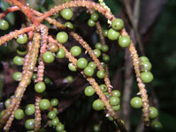
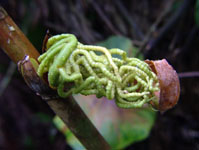
| Field notes | Cespitose understory palm with few visible roots. Stem 1.1 m tall, 0.8 cm thick, smooth, green to cream; internodes 3 cm long. Leaves 9; leaf sheath 10 cm long, open; petiole 15 cm long, section margined; rachis 40 cm long; lamina pinnate, 65 cm long, 25 cm wide, glabrous, pinnae inserted in groups of 5; basal pinna 26 cm long, middle pinna 36 cm long, apical pinna 36 cm long. Inflorescence infrafoliar; prophyll 5 cm long, 4 cm wide, papery; peduncular bract 5 cm long, inserted 6 cm from base, brown, papery; peduncle 7 cm long, 0.5 cm wide; rachis 10 cm long, 0.4 cm wide; rachillae 12, 10-15 cm long. Flowers cream, sunken. Fruits light green, 0.4 cm long, 0.4 cm wide. Transect HB140, subunit no. 003, inside transect; UTM: 20K-310929-8107934 |