AAU Herbarium Database |
| New Search Modify Search |
| Collector | Balslev, H. |
| Number | 8239 |
| Collected with | Dennis Pedersen, Narel Paniagua Zambrana, Manual Macia & Alexander Parada |
| Country | Bolivia |
| Subpart | Cochabamba/Beni |
| County | |
| Locality | 120 km NE of Cochabamba, 1.5 km NE of the San Benito village, next to the Isiboro river. Primary floodplain forest |
| Coordinates | 16° 31' 13.7'' S 65° 30' 11.9'' W |
| Minimum elevation (m) | 218 |
| Maximum elevation (m) | 218 |
| Start date | 2010/03/25 |
| End date | 2010/03/25 |
| Family | Arecaceae |
| Identification | Bactris chaveziae A.J.Hend. |
| Determined by | Balslev H. |
| Identification qualifier | |
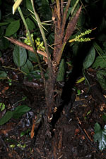
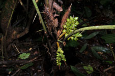
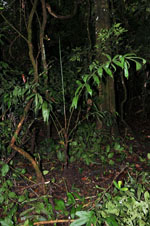
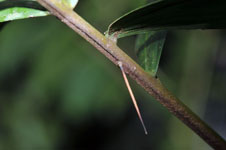
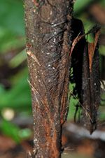
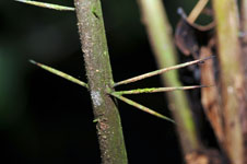
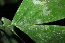
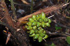
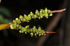
| Field notes | Solitary understory palm. Stem 30 cm long, 2 cm thick, brown, covered by leaf bases; internodes 4 cm long. Leaves 4; sheath open; petiole 85 cm long, section round, with brown spines to 3 cm long; rachis 84 cm long, with brown spines to 4 cm long; lamina pinnate, 108 cm long, 65 cm wide, glabrous; pinnae per side 12, regularly inserted; basal pinna 34 cm long, middle pinna 28 cm long, apical pinna 31 cm long. Infructescence: peduncular bract 16 cm long, brown, woody, with brown spines to 1 cm long; peduncle 9 cm long, 1 cm wide; rachis 6 cm long, 0.5 cm wide. Fruits 2 cm long, 1 cm wide, green. Local name: Marayas. Informant: Rodolfo Noza. Transect HB128, SU 087; UTM 20K-232799-8171831, in transect |
| |
 Other records of Bactris chaveziae Other records of Bactris chaveziaeThe map displays only records from the Aarhus Herbarium Database. The records may not represent the full distribution of Bactris chaveziae |
| New Search Modify Search |