AAU Herbarium Database |
| New Search Modify Search |
| Collector | Balslev, H. |
| Number | 8211 |
| Collected with | D. Pedersen, L.S. Damgaard, K.Ø. Madsen, A. Alvarado, A. Serralta, A. Moo, O. Alvarado, R. Duno, G. Dzib & L.M. Calvo |
| Country | Mexico |
| Subpart | Quintana Roo |
| County | |
| Locality | Municipio Othón P. Blanco. 88 km SW of Chetumal, 11 km SW of the village of Ejido Caobas (La Guadalupe). Semievergreen tropical rainforest on limestone |
| Coordinates | 18° 20' 35.5'' N 89° 7' 12.1'' W |
| Minimum elevation (m) | 152 |
| Maximum elevation (m) | 0 |
| Start date | 2010/02/24 |
| End date | 0/00/00 |
| Family | Arecaceae |
| Identification | Chamaedorea seifrizii Burret |
| Determined by | H. Balslev |
| Identification qualifier | |
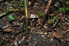
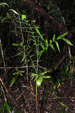
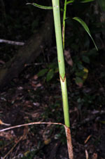
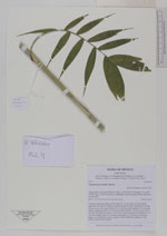
| Field notes | Cespitose understory palm. Sterile. Stem 65-133 cm long, 0.6-0,8 cm thick, upper part covered by leafbases, smooth towards the base; internodes 9 cm long, green. Leaves 5 per stem; sheath 12.5-16 cm long, closed; petiole 5-11 cm long, section margined; rachis 14-25 cm long; lamina pinnate, 18-26 cm wide, 20-32 cm long, flat, glabrous; pinnae 5-8 per side, insertion regular, basal pinna 8-11.5 cm long, middle pinna 9-13 cm long, apical pinna 7-12 cm long. Vernacular name: x·yat. Informant: Carlos Varguez Transect HB1540, subunit no. 053; UTM 16Q-0275964-2029462 |
| |
 Other records of Chamaedorea seifrizii Other records of Chamaedorea seifriziiThe map displays only records from the Aarhus Herbarium Database. The records may not represent the full distribution of Chamaedorea seifrizii |
| New Search Modify Search |