| Collector | Balslev, H. |
| Number | 8196 |
| Collected with | D. Pedersen, L.S. Damgaard, K.Ø. Madsen, A. Alvarado, A. Serralta, A. Moo, O. Alvarado, R. Duno, G. Dzib & L.M. Calvo |
| Country | Mexico |
| Subpart | Quintana Roo |
| County | |
| Locality | Municipio Othón P. Blanco. 84.5 km SW of Chetumal, 19.5 km SE of the village of Ejido Caobas (Chichán ja). Semievergreen tropical rainforest on limestone |
| Coordinates | 18° 16' 18.4'' N 89° 3' 55.5'' W |
| Minimum elevation (m) | 196 |
| Maximum elevation (m) | 0 |
| Start date | 2010/02/22 |
| End date | 0/00/00 |
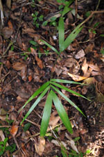
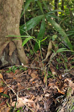
| Family | Arecaceae |
| Identification | Gaussia maya (Cook) H.J.Quero & Read |
| Determined by | H. Balslev |
| Identification qualifier | |
| Field notes | Juvenile. Vernacular name: K'ambó. Informant: Carlos Varguez. Transect HB1536, subunit no. 064; UTM 16Q-0281648-2021488 |
|
 Other records of Gaussia maya