| Collector | Balslev, H. |
| Number | 8184 |
| Collected with | D. Pedersen, L.S. Damgaard, K.Ø. Madsen, A. Alvarado, A. Serralta, A. Moo, O. Alvarado, R. Duno, G. Dzib & L.M. Calvo |
| Country | Mexico |
| Subpart | Quintana Roo |
| County | |
| Locality | Municipio Othón P. Blanco. 83 km W of Chetumal, 24 km SE of the village of Ejido Caobas, camino a Jaguactal. Semievergreen tropical rainforest on limestone |
| Coordinates | 18° 14' 10.3'' N 89° 3' 18.8'' W |
| Minimum elevation (m) | 176 |
| Maximum elevation (m) | 0 |
| Start date | 2010/02/21 |
| End date | 0/00/00 |
| Family | Arecaceae |
| Identification | Gaussia maya (Cook) H.J.Quero & Read |
| Determined by | H. Balslev |
| Identification qualifier | |
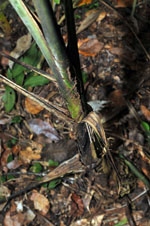
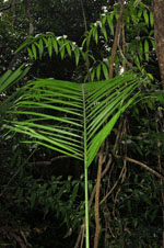
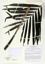
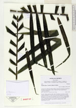
| Field notes | Juvenile. Solitary understory palm. Stem 25 cm long, 9 cm wide, covered by leafbases; internodes 1 cm long. Leaves 4 per stem; sheath open, 34 cm long; petiole 100-118 cm long, section margined; rachis 115-144 cm; lamina pinnate, flat, glabrous; pinnae 36-40 per side, basal pinna 20-24 cm long, middle pinna 34-37 cm long, apical pinna 10-15 cm long. Vernacular name: K'ambó. Informant: Carlos Varguez. Transect HB1534, subunit no. 087; UTM 16Q-0284683-2017538. |
|
 Other records of Gaussia maya