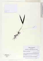
| Collector | Balslev, H. |
| Number | 8145 |
| Collected with | D. Pedersen, L.S. Damgaard, K.Ø. Madsen, A. Alvarado, A. Serralta, A. Moo, O. Alvarado, R. Duno, G. Dzib & L.M. Calvo |
| Country | Mexico |
| Subpart | Quintana Roo |
| County | |
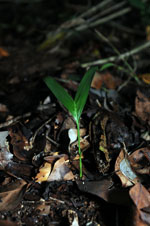
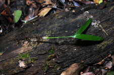
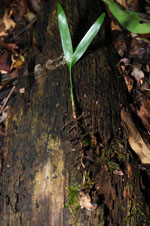
| Locality | Municipio Lázaro Cárdenas. 45 km W of Cancún, 23 km NE of the village of Kantunilkín. Ch'en Cura. Semievergreen tropical forest on shallow soil, on limestone |
| Coordinates | 21° 8' 31.8'' N 87° 16' 9.5'' W |
| Minimum elevation (m) | 17 |
| Maximum elevation (m) | 0 |
| Start date | 2010/02/06 |
| End date | 0/00/00 |
| Family | Arecaceae |
| Identification | Chamaedorea seifrizii Burret |
| Determined by | H. Balslev |
| Identification qualifier | |
| Field notes | Seedlings. Vernacular name: X·yat, informant: Lázaro Chimal. Transect HB1501, subunit no. 052; UTM 16Q-0472037-2337905. No DNA |
|
 Other records of Chamaedorea seifrizii