| Collector | Balslev, H. |
| Number | 8136 |
| Collected with | C. Grandez, D. Pedersen, B. Bergmann, G. del Aguila Panduro, Jim Chilo, A. Alvarado & J. Gonzales Baardales |
| Country | Peru |
| Subpart | Loreto |
| County | |
| Locality | 26 km SW of Iquitos. Río Itaya. Village of Soledad, about 40 min walk to the west, towards the Iquitos-Nauta rd. Remnants of tropical rain forest on terra firme. UTM 18M: 679948; 9560999 |
| Coordinates | 3° 58' 12.4'' S 73° 22' 45.1'' W |
| Minimum elevation (m) | 128 |
| Maximum elevation (m) | 0 |
| Start date | 2009/07/13 |
| End date | 0/00/00 |
| Family | Arecaceae |
| Identification | Attalea tessmannii Burret |
| Determined by | Balslev H. |
| Identification qualifier | |
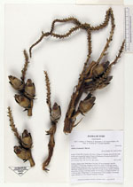
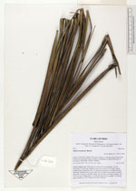
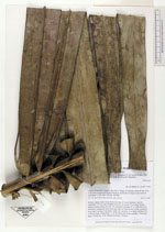
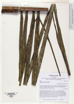
| Field notes | Solitary canopy palm. Stem about 6 m long, 43 cm in diameter, smooth; internodes 7-13 cm long. Number of leaves 16; rachis 9.3 cm long; lamina pinnate, bushy; pinnae per side 219, inserted in groups of 1-4. Infructescence interfoliar; peduncular bract more than 285 cm long, brown, woody; peduncle more than 1 m long, 6 cm thick; rachis 183 cm long, 6 cm thick; rachillae 170, 10-40 cm long. Young fruits 1-2 on the basal part of the rachillae. Vernacular name: chonta, acc. to Sr. Manuel Gonzales, Soledad. |
|
 Other records of Attalea tessmannii