AAU Herbarium Database |
| New Search Modify Search |
| Collector | Balslev, H. |
| Number | 8119 |
| Collected with | C. Grandez, D. Pedersen, B. Bergmann, G. del Aguila Panduro, Jim Chilo, A. Alvarado & J. Gonzales Baardales |
| Country | Peru |
| Subpart | Loreto |
| County | |
| Locality | Río Amazonas, 90 km NE of Iquitos. Village of Roca Eterna, aprox. 4 km N of village. Primary forest on tierra firme. UTM 18M: 776886; 9619531 |
| Coordinates | 3° 26' 20.1'' S 72° 30' 28.9'' W |
| Minimum elevation (m) | 98 |
| Maximum elevation (m) | 0 |
| Start date | 2009/07/10 |
| End date | 0/00/00 |
| Family | Arecaceae |
| Identification | Geonoma macrostachys var. macrostachys Mart. |
| Determined by | Balslev H. |
| Identification qualifier | hybrid brongniartii |
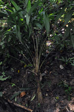
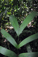
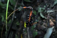
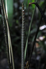
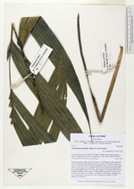
| Field notes | Solitary understory palm, Stem 26 cm long, 3 cm in diameter, rough; internodes to 0.5 cm long; base with visible roots to 20 cm long, 0.3 cm thick. Number of leaves 15; sheath+petiole 52 cm long, sheath open; rachis 26-30 cm long; lamina pinnate; pinnae more or less regularly inserted, in one single plane, basal pinna 41 cm long, middle pinna 39 cm long, apical pinna 31.5 cm long. Infructescence interfoliar; prophyll 13 cm long, 1 cm wide, papery; peduncle 27 cm long, 0.4 cm thick, green; spike 14 cm long, 1 cm thick, red. Fruits black. (Infructescence of G. macrostachys; stem and leaves of G. brogniartii see HB 8120). HB transect 404, subunit 19. |
| |
| Display all 220 georeferenced records of Geonoma Geonoma macrostachys var. macrostachys |
| New Search Modify Search |