AAU Herbarium Database |
| New Search Modify Search |
| Collector | Balslev, H. |
| Number | 8109 |
| Collected with | C. Grandez, D. Pedersen, B. Bergmann, G. del Aguila Panduro, Jim Chilo, A. Alvarado & J. Gonzales Baardales |
| Country | Peru |
| Subpart | Loreto |
| County | |
| Locality | Río Marañon, 47 km SW of Iquitos. Km 47 on Iquitos - Nauta rd. Disturbed primary forest on moderate slopes. UTM 18M: 668422; 9542925 |
| Coordinates | 4° 8' 1.6'' S 73° 28' 57.7'' W |
| Minimum elevation (m) | 149 |
| Maximum elevation (m) | 0 |
| Start date | 2009/07/07 |
| End date | 0/00/00 |
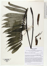
| Family | Arecaceae |
| Identification | Bactris hirta var. lakoi (Burret)A.J.Hend. |
| Determined by | Balslev H. |
| Identification qualifier | |
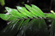
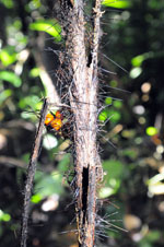
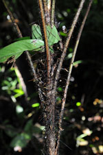
| Field notes | Solitary understory palm. Stem 54 cm long, 2 cm in diameter, covered by old leaf sheaths. Leaves 7; leaf sheath 14 cm long, petiole 31 cm long; rachis 39 cm long, sheath, petiole and rachis with spines; lamina pinnate, flat, hairy; pinnae 18 per side, inserted in groups of 1-7, basal pinna 18 cm long, middle pinna 13 cm long, apical 8 cm long. Infructescence infrafoliar; prophyll 5 cm long, 1 cm wide, papery; peduncular bract 8 cm long, brown with black spines; peduncle 8 cm long; rachis absent; rachillae 2, 4.5 cm long. Fruits globose, orange. HB transect no. 403, subunit 86 |
| |
 Other records of Bactris hirta var. lakoi Other records of Bactris hirta var. lakoiThe map displays only records from the Aarhus Herbarium Database. The records may not represent the full distribution of Bactris hirta var. lakoi |
| New Search Modify Search |